By Hussaini Umar
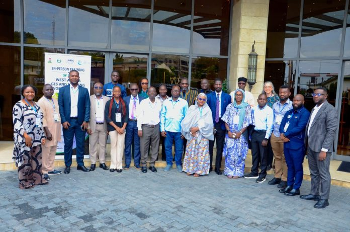
ABUJA — Technical experts from 12 West African countries have begun a regional Geographic Information System (GIS) training programme aimed at strengthening scientific mapping of biodiversity as governments work toward achieving the global target of conserving 30 percent of land and marine ecosystems by 2030.
The week-long programme brings together GIS and remote sensing specialists from across the Economic Community of West African States (ECOWAS) to improve the region’s ability to identify biodiversity hotspots, map degraded ecosystems, monitor endangered species and support evidence-based conservation planning.
The initiative is supported by the Natural Resources Defense Council (NRDC) and the High Ambition Coalition for Nature and People.
At a Glance
| Indicator | Value |
|---|---|
| Countries participating | 12 |
| Conservation target | 30% of ecosystems by 2030 |
| Target year remaining | About 4 years |
| Global biodiversity framework | Kunming-Montreal GBF |
| Key GIS focus areas | Mapping, Monitoring, Restoration |
The 12 Countries Working Together
The regional GIS Working Group includes experts from:
- Benin
- Burkina Faso
- Côte d’Ivoire
- The Gambia
- Ghana
- Guinea
- Liberia
- Niger
- Nigeria
- Senegal
- Sierra Leone
- Togo
Regional Participation

■■■■■■■■■■■■
12 Countries
1 Regional Goal
What Does “30 by 30” Mean?
The global “30 by 30” initiative aims to ensure that at least 30 percent of the world’s:
- Land
- Inland waters
- Coastal ecosystems
- Marine ecosystems
are effectively protected and conserved by 2030.
It forms one of the central commitments under the Kunming-Montreal Global Biodiversity Framework (KM-GBF) adopted by nearly 200 countries.
Why GIS Matters for Conservation
Environmental conservation increasingly depends on data rather than guesswork.
GIS technology enables governments to:
- Map forests and wetlands
- Identify endangered species habitats
- Detect illegal land-use changes
- Prioritise ecosystem restoration
- Monitor conservation progress over time
Without reliable geospatial information, governments risk investing in protected areas that may not safeguard the most critical biodiversity.
West Africa As a Global Biodiversity Hotspot
According to biodiversity experts, West Africa contains:
- Tropical forests
- Mangrove ecosystems
- Savannahs
- Freshwater wetlands
- Coastal habitats
These ecosystems provide:
- Food security
- Clean water
- Climate regulation
- Pollination for agriculture
- Livelihoods for millions of people
However, many face growing pressure from:
- Deforestation
- Urban expansion
- Agricultural conversion
- Mining
- Climate change
- Illegal wildlife exploitation
The Three Main Biodiversity Targets
The GIS programme directly supports the first three targets of the Kunming-Montreal Framework.
| Target | Objective |
|---|---|
| Target 1 | Biodiversity-inclusive spatial planning |
| Target 2 | Restore degraded ecosystems |
| Target 3 | Protect 30% of ecosystems by 2030 |
These objectives require accurate maps, updated environmental data and cross-border cooperation.
Conservation Is Increasingly a Regional Challenge
Wildlife and ecosystems do not respect national borders.
For example:
- Rivers flow across multiple countries.
- Forests extend beyond political boundaries.
- Migratory birds travel thousands of kilometres.
- Large mammals often move between neighbouring protected areas.
Regional mapping therefore enables governments to coordinate conservation rather than working in isolation.
Why Funding Remains Critical
While improved technical capacity is essential, experts say achieving the region’s biodiversity ambitions will also depend on closing significant financing gaps.
Priority investments include:
- Satellite imagery
- GIS software and hardware
- Biodiversity monitoring
- Ranger operations
- Restoration projects
- Community conservation initiatives
Without sustained domestic and international funding, many conservation plans may remain difficult to implement.
What Success Could Look Like
If successfully implemented, the regional conservation strategy could help:
- Protect endangered wildlife
- Reduce biodiversity loss
- Restore degraded forests and wetlands
- Improve climate resilience
- Secure ecosystem services
- Support sustainable agriculture
- Strengthen ecotourism
- Improve livelihoods across West Africa
The Bigger Picture
The Abuja training reflects a broader shift in environmental governance—from protecting isolated parks to using geospatial intelligence to guide conservation across landscapes and national borders.
With only a few years remaining until the 2030 “30 by 30” deadline, the ability of West African countries to generate accurate environmental data may prove as important as political commitment itself. By investing in GIS capacity today, the region is laying the scientific foundation for more effective biodiversity protection, climate resilience and sustainable development.
Key Numbers
| Metric | Figure |
|---|---|
| Participating countries | 12 |
| Global conservation target | 30% |
| Target completion year | 2030 |
| Kunming-Montreal priority targets supported | 3 |
| Regional GIS Working Group | 1 |
Data Sources
- West Africa GIS and Mapping Working Group
- ECOWAS biodiversity initiatives
- Kunming-Montreal Global Biodiversity Framework (KM-GBF)
- Natural Resources Defense Council (NRDC)
- High Ambition Coalition for Nature and People